DigArch - Archaeological Record Keeping System
Let’s leave paper-based data storage in the past
/1.Brief / Whyyyyy?
Client
The Archaeology Department of the Satu Mare County Museum approached us with the exciting task of digitizing the data collected during excavations and making it accessible to other researchers.
The system provided by the national Ministry of Culture, unfortunately, doesn't meet the practical needs of archaeologists: the data can only be accessed on local servers, and even uploading it is possible only on-site. This not only complicates the work but makes collaboration almost impossible.
In contrast, we designed and developed a system that is as easy to use for archaeologists working in the field as it is for those who want to explore previously uncovered data for new research or uncover fresh connections.
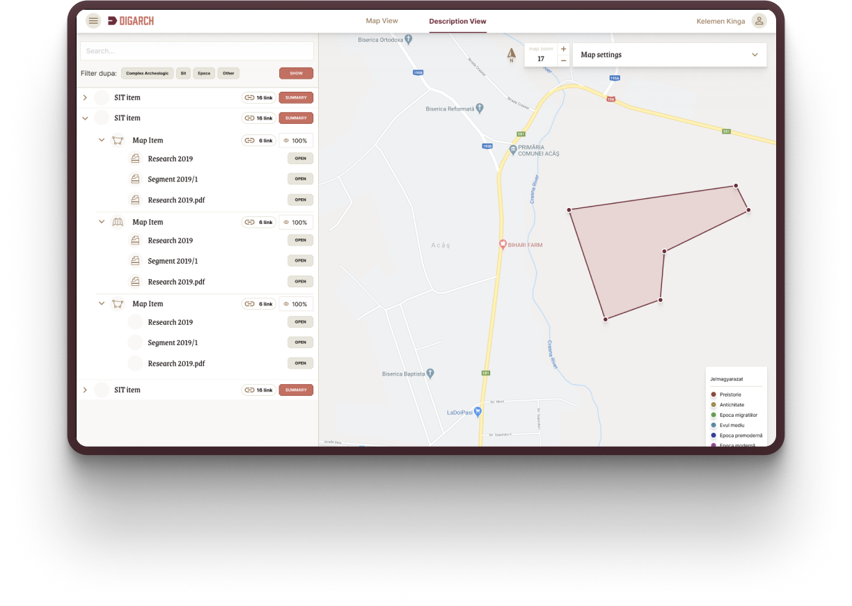
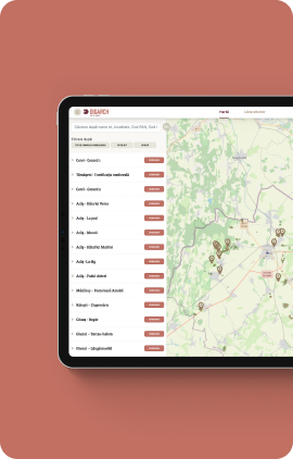
On the new platform, all data is available in a transparent, easily searchable system: research results, reports, photos, drawings, maps, and topographic measurements.
Tools & Technology:
#Jira #Agile #figma #miro #reactjs #php #laravel #mySQL #leafletjs #geotiff #Qgis #tailwind #phpword
Team members:
Archaeologist
Sebestyén Róbert - Project Management
Györfi Sándor - UX
Péter Botond - UI
Buksa Kinga - Developer
Kiss Csaba - Developer
What we worked on:
Identity design
UX & UI Design
Development
DevOps
Project management
Testing
Implementation
DigArch - Archaeological Record Keeping System
Challenges and solutions
How we worked
Throughout the project, we worked closely with the client, following an agile methodology. This allowed us to continuously adapt to changing needs and quickly respond to emerging challenges. The archaeological team played a key role, providing domain-specific knowledge that ensured we met all the professional requirements during the development process.
Special thanks to the Department of Geography at Babeș-Bolyai University, whose expertise contributed to the successful transition from the Stereo 70 projection system to WGS 84, which was critical to the project's success.
/2.Workflow
- 01. problem discovery
- 02. wireframe and interactive prototype
- 03. Identity design
- 04. architecture design
- 05. content management system
- 06. map projections preparation and development
- 07. graphic design and development
- 08. testing and debugging
- 09. deployment and handover


Yes, a shovel, what else...
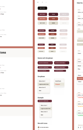
When developing a web application for a small expert audience, many think that branding doesn’t require much effort. However, we felt that well-thought-out and consistent visual elements not only made the interface more attractive but also improved its usability.
For the color palette, we based it on earthy tones, highlighted with terracotta red, commonly used in ceramics. In the case of an archaeological digitization application, this probably doesn’t need much explanation.
The shovel, as a symbol, was also an obvious choice, as it’s one of the essential tools in excavations. The contour decorations on the interface further enhance the geographical and archaeological context, as this is a location-based digitization and archiving system.
Wireframe
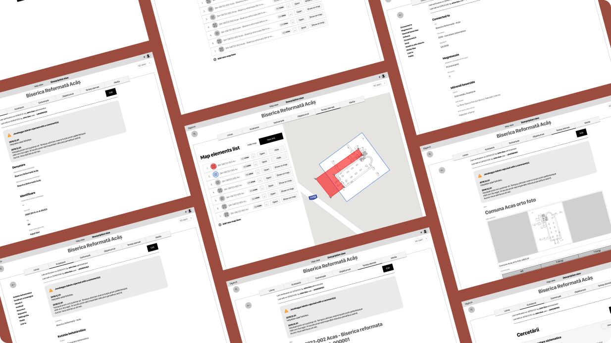
Due to the complexity of the project, it was essential to test our ideas in practice before designing the UI. This way, we could ensure that the client not only understood how the interface would work, but if any changes were needed, we could implement them cost-effectively.
The interactive wireframe was a huge help to the developers as well, as they could see what data they would need to work with before the design was finalized. It also became clear which elements worked well on certain interfaces and which didn’t. These aspects are often hard to foresee from a technical specification, but the wireframe saved countless hours during development.
/3.Solutions
DigArch is always online
One of the system’s greatest advantages is that it is accessible from anywhere, which was a key requirement from the client. They didn’t want a system installed only on local computers or the organization's server, but one that could be accessed remotely.
This proved particularly useful during the Covid pandemic when the entire institution was forced to work remotely. Although they couldn’t conduct new excavations for a long time, research and data processing continued without interruption, and the work never stopped.
Archaeologist-friendly system
Even implementing a relatively simple system can be a challenge if the developers and clients don’t speak the same language or think in the same way. That’s why we put a lot of emphasis on thoroughly mapping out existing processes and dependencies during the project. This ensured a smooth transition and made it easier for the staff to adapt to the new system without too much headache.
When designing the IT system, we aimed to partially reflect the real world and existing systems, so the new solution would seamlessly integrate with previous processes. This not only made the implementation smoother but also facilitated a more seamless transition.
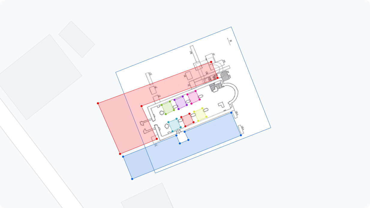
Inserting map sections
For a long time, it wasn’t clear why cartographic sections or layers were so important in the study of historical periods. But when we consider how often a place’s function changes over the course of our lives, it becomes easier to understand. Over centuries, even greater changes may have occurred. For example, where a highway runs today, significant battles took place during the 1848 Revolution.
Therefore, it’s essential for researchers to easily upload and accurately position these layers. We developed a solution that allows for the precise positioning of map sections by matching the corners of image files. Additionally, it supports the upload of TIF files generated from geographic information systems.
This solution greatly aids research by allowing for a quick and accurate overview of connections between different historical periods.
A new perspective for researchers
With the DigArch system, we vividly display the polygonal representations of excavation sites on historical, military, or cadastral maps. This allows for the discovery and interpretation of connections that were previously impossible with traditional archaeological record-keeping systems. This visual representation opens up new perspectives for researchers and greatly enhances the deeper analysis of historical data.
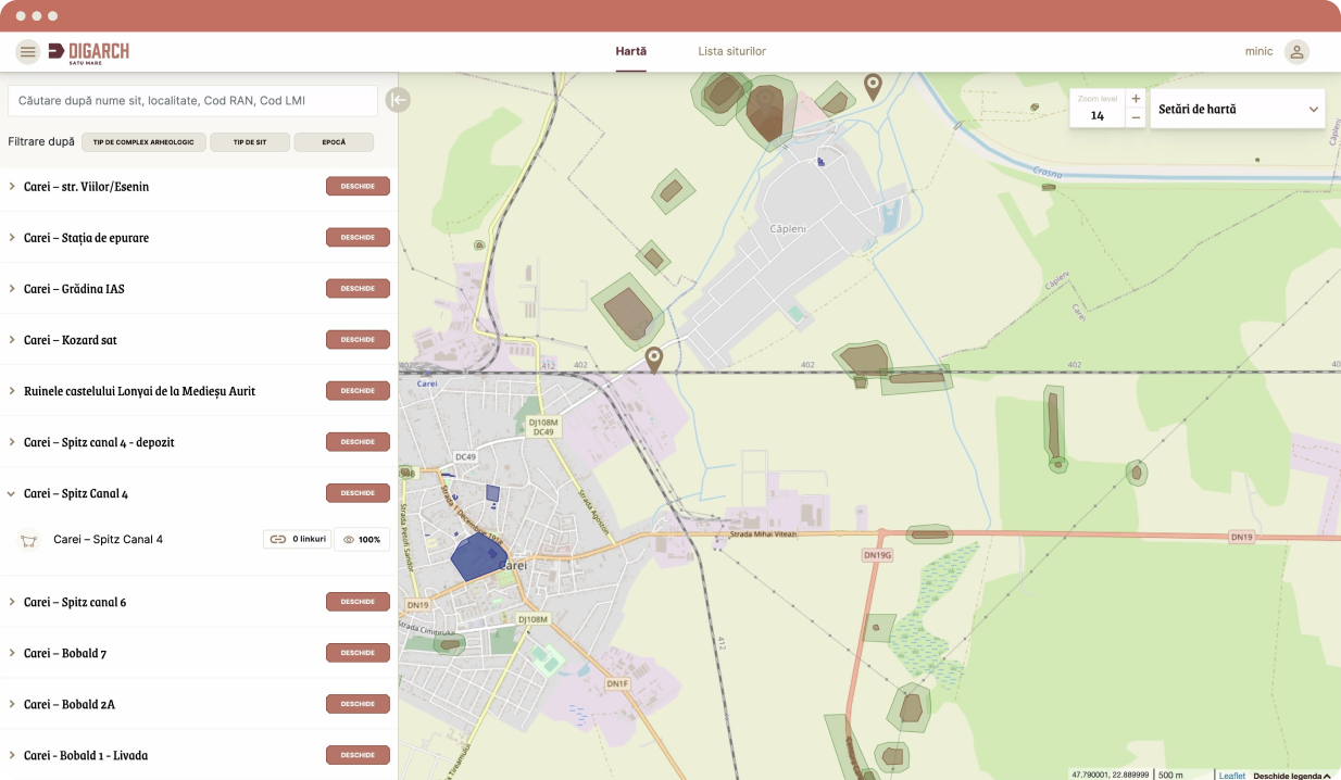
Site preservation
The previously mentioned map visualization plays a crucial role in the preservation of archaeological sites. By highlighting areas where significant historical events took place, necessary precautions can be taken in time at endangered locations. This allows researchers and decision-makers to more easily identify risky areas and implement more effective protective measures to safeguard these sites.
What is stereo 70?
The Stereo 70 projection system is a specialized geographic projection developed specifically for Romania, primarily used for cartographic and geodetic purposes. It is a modified version of the Gauss-Krüger transverse Mercator projection, based on a stereographic projection centered at 45°N latitude and 25°E longitude.
The client required that their maps and geographic coordinates georeferenced in the Stereo 70 system be displayed in modern, open-source mapping software, such as OpenStreetMap, using the WGS84 projection system. This conversion posed significant challenges because the two projection systems are based on different surfaces and mathematical models.
To successfully carry out these conversions, we received expert support from the Department of Geography at Babeș-Bolyai University, which helped us develop precise mathematical transformations. These transformations enabled the conversion between Stereo 70 and WGS84 systems, ensuring the correct display of maps and coordinates in modern geographic information tools.
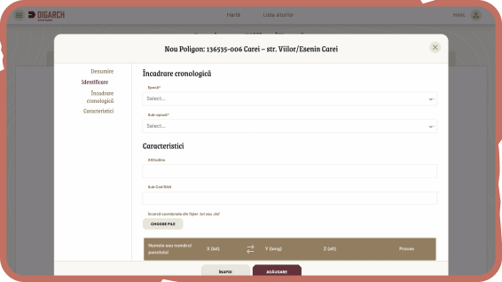
Uploading coordinates from GPS data
We offer several options for recording site coordinates, simplifying fieldwork. Points recorded with GPS are processed from a .dxf file and converted into polygons. Additionally, users can manually define the corners of the site, or a list of points stored in a .txt file can be converted into a polygon. At the end of the process, the precise location of the site is displayed on the map, making it easily identifiable.
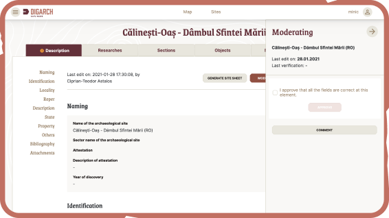
Content moderation
Data recording during research is carried out under strict supervision. Therefore, we have integrated a moderation feature into our system, ensuring that data is only made available after administrative approval. In addition, there is the option to request corrections or reject changes, ensuring the accuracy and reliability of the data at all times.
/4.Results
In a short period of time, we were able to clearly define what was needed, what must be included in the DigArch database, and which features would make the archaeologist's job easier.
Every discussion with the team led to positive outcomes. These conversations were often informal; we shared laughs or occasionally felt frustration during certain work phases. One of the most positive attributes of the team, especially project manager Róbert Sebestyén, was their flexibility, which characterized the entire execution period.
One of the most challenging aspects of the project was developing the geoinformatics interface. On my end, I had to prepare raw material maps, which required a lot of energy, while for the development team, converting the coordinates was one of the biggest challenges. I believe that even in this situation, thanks to the team's excellent communication skills, we were able to streamline the work.
Since 2020, we have been using the DigArchSm cloud-based database. In the initial phase, we uploaded materials from 250 archaeological sites, and today that number has grown to around 350. Initially, the focus was on documentation, but now we are expanding the digital archive, which allows us to access the documents we need anytime, from anywhere.
The database has also reduced our bureaucratic workload, as it enables us to generate standardized archaeological records directly from the system.
We hope that the area-based record-keeping system of the DigArchSm database will ensure that our work leaves a lasting mark for future generations, while also simplifying the field identification of archaeological sites.
ClutchKey achievements
- With DigArch, we made data access more efficient.
- We simplified administrative processes.
- Time was saved by automating the generation of site reports.
- We made archaeologists' work easier.
- We opened up a new perspective for researchers with map visualization.
- We enabled more effective collaboration.
- We allowed for more flexible work, enabling more research to be completed.
- We increased data security.
Number of sites
Number of artifacts
Nr. of users
Diploma thesis contribution
/5.Credits
Archaeologist
Belbe Sebastian
Project Management
Sebestyén Róbert
UX/UI
Györfi Sándor
Péter Botond
Branding
Péter Botond
Development
Buksa Kinga
Kiss Csaba
